
 How did Adam and the animals get their names?
“And out of the ground, the LORD God formed every beast of the field and every fowl of the air; and brought them unto Adam to see what he would call them: and whatsoever Adam called every living creature that was the name thereof. And Adam gave names to all cattle, and to the fowl of the air, and to every beast of the field…” (Gen 2:19-20).
Euphrates and Mesopotamia
The Tigres and Euphrates Rivers dominate Mesopotamia. Both rivers originate in the high mountains foe aster Turkey and flow south-Southeastward to the Persian Gulf.
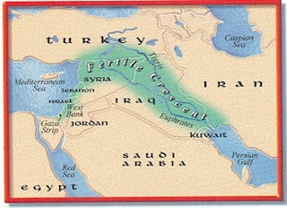
Mesopotamia is Greek for “between the rivers.”
Specifically, the rivers referenced by this term are the Tigris and Euphrates Rivers that run through modern-day Iraq.
These two rivers, and the land between them, are often called the “cradle of civilization” because the civilization that developed there was likely the first ever on Earth.
If we go back to the characteristics of a civilization, we know that one of the first requirements is a surplus of food.
It makes sense then that the people that settled in Mesopotamia did so to utilize the life (and food) giving waters of the Tigris and Euphrates rivers.
Like other river valley civilizations (Egypt, the people of the Indus River Valley), the people of Mesopotamia relied heavily on fairly regular spring floods that spilled the rivers over their banks, leaving behind extremely fertile soil when the waters receded.
The melting snows that fed the Tigris and Euphrates mountains came from the Taurus Mountains to the northwest in modern Turkey and the Zagros mountains to the north in Iran and Turkey.
The Tigris and Euphrates were of course used as a water supply and to irrigate crops, but they were also important for transportation and trade.
Mesoptamia was a cross-roads of the early ancient world for trade between Egypt, India and China, and the people leaving on the eastern shores of the Mediterranean, a region called the Levant.
Like most of the great rivers of the world, the Tigris and Euphrates have been dammed to control flooding and harness the power of the moving waters.
As a result, Mesopotamia is much less “green” in modern satellite images than it would have appeared even a few centuries ago.
The deserts have reclaimed much of the land between the rivers, including much of the marshlands that were once plentiful there.
The deserts also reclaimed a chunk of the Persian Gulf, where the Tigris and Euphrates Rivers join and empty.
Large distances separate the rivers for most of their journey, but near Baghdad they converge to within 20 miles. Near the head of the Persian Gulf the rivers merge into a marshland, a feature characteristic of both ancient and modern times.
The Euphrates (1,780 miles long) is longer and slower than the Tigris (1,150 miles long), but more suited for transportation. All important cities of Mesopotamia are along one of the two rivers.
Both rivers flooded annually, bringing damage to the cities. Central and southern Mesopotamia maintained sophisticated system of canals, dikes, and dams from earliest times to protect their cities and to distribute water to thirsty fields.
Southern and northern Mesopotamia differs in terms of geography, climate, and natural resources.
The dividing line between the two is roughly near modern Baghdad, approximately 350 miles.
In the north the summers were very hot, winter’s mild, rainfall scarce, so crops depended entirely on irrigation.
The south lacks many resources; few building materials were available so houses, temples, and palaces were built of mud brick. Metals and timber had to be imported.
Yet, crops of barley were excellent, the basic staple used for cakes, beer, and some wheat.
Dates grew in abundance and sesame oil supplied essential carbohydrates for the diet. Fish from the marshlands and rivers provided much of the meat.
Babylon and Ur prospered greatly from the vitality of the Mesopotamia area.
North of Baghdad, uplands and steppes contrast with flat plain of the south. Rolling hills emerge from the high mountains that border Mesopotamia to the north.
Rainfall amounts are higher here; some sections received up to 20 inches annually. Summers are somewhat milder than in the south, but winters harsher due to the higher elevations.
Near Mosul in the middle Tigris Valley; Asshur, Nineveh, and Calah (Nimrud) mark the heartland of ancient Assyria.
Portions of Assyria produced crops of barley and wheat, but not enough for them to be self-sufficient. Metals necessary for weapons and implements – copper, iron, tin, zinc, and lead – had to be imported along with cedar and food supplies.
Due west of Assyria lay northwest Mesopotamia associated with the Balikh and Habor Rivers.
Today it is a small town in the province of Balkh, about 20 kilometers northwest of the provincial capital, Mazar-e Sharif, and some 74 km (46 mi) south of the Amu Darya.
It was one of the major cities of Khorasan, since the latter’s earliest history. Marco Polo described Balkh as a “noble and great city”.
The ancient city of Balkh was under the Greeks renamed Bactra, giving its name to Bactria.
It was mostly known as the center and capital of Bactria or Tokharistan.
Balkh is now for the most part a mass of ruins, situated some 12 km from the right bank of the seasonally flowing Balkh River, at an elevation of about 365 m (1,200 ft).
Outside the town was a large Buddhist monastery, later known as Naubahar.
Balkh is considered to be the first city to which the Indo-Iranian tribes moved from the North of Amu Darya, between 2000 – 1500 BC.
The Arabs called it Umm Al-Belaad or Mother of Cities due to its antiquity.
The city was traditionally a center of Zoroastrianism.
The name Zariaspa, which is either an alternate name for Balkh or a term for part of the city, may derive from the important Zoroastrian fire temple Azar-i-Asp.
Balkh was regarded as the place where Zoroaster first preached his religion, as well as the place where he died.
The Bible associates Abraham closely with this region. The biblical term Aram-naharaim (Gen 24:10, Deut 23:4), often translated Mesopotamia,” refers to the land of the Balikh and Habor Rivers.
You will hear more about Nineveh, mostly in the book of Jonah. It was extremely powerful and cruel.